


Settlement Development: Settlement Patterns and Morphology
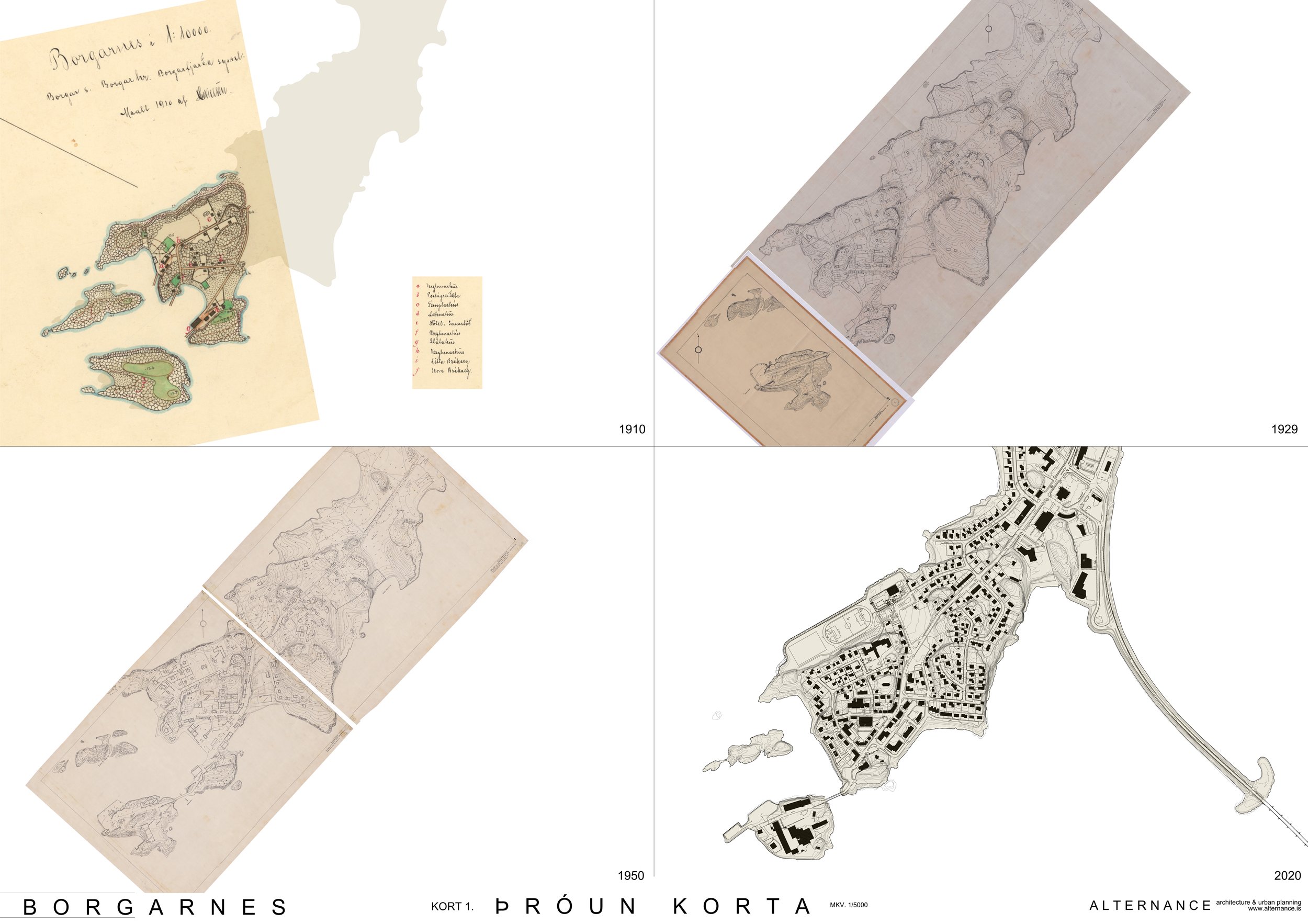
Urban areas are complex phenomena that reflect the history, culture, technical skills, economy and values of the inhabitants during the different growth periods of the settlement. By examining the organizational characteristics of the urban area, the environmental, social and economic motivations behind the formation of the built form can be identified. Urban landscape consists of planning, settlement patterns and land use patterns, and the latter changes the fastest. To understand the urban landscape, it is necessary to trace the development process of the settlement from the beginning to the present day, and there are numerous maps of Borgarnes from different eras. During the processing of this study, four maps of Borgarnes were selected that show the town at different times. The oldest map from 1910 and the youngest from 2022, together with two in between, clearly and clearly show the growth and development of the settlement over more than a century. The methodology of urban morphology is based on the fact that planning plans can be read like any other historical document, if the right approach and methodology are used. Planning lays the foundation for the man-made environment, because in planning the topological arrangement of the man-made environment is determined, i.e. location of buildings, streets and open spaces. In this way, the framework of human behavior is formed and the arena of the daily life of the inhabitants is created. At the same time, the plan has a physical connection to the location and history of the area.

Development of MAPS
The oldest monuments in Borgarnes are believed to be from the 9th century, but the oldest map is from the year 1910. The map shows how the settlement begins to develop on the west side of the promontory, where the boat anchorage is most suitable. Single wooden houses are built near upsats at a reasonable distance from the sea and where they are best protected from the weather and winds. Piers are built like that and the most important buildings stand next to them. Clear lines have been added to the route system, which now includes Borgarbraut, Gunnlaugsgata, Skúlagata and Egilsgata. The maps from 1929 and 1950 show how the settlement in the west starts to become denser and stretches out into Brákarey and inland. Skallagrímshaug, Kveldúlfshaug, Brennuholt and Varða,
Brákarsund, Brákarpollur and Neðri-Sandvík are listed on both maps, which can therefore be assumed to have been the main landmarks of the town. Location of rocks, grassland, rocky beaches and sandy beaches/islands is very clear on the maps. If you look at the morphology of the built landscape, the triangular shape is characteristic of the old part of Borgarness. On the map from 2022, you can see how the settlement has concentrated over almost the entire headland and the shopping and service area at the edge of the Borgarfjarðar Bridge has become a reality. The town has grown in step with the rocky landscape, which surrounds the settlement in a beautiful way.entreprise.


Roads & Paths
A clear distinction is made between different tides on the old maps. At the beginning of the settlement, there are clearly many raids and important for the development of the settlement. The first streets, Borgarbraut, Gunnlaugsgata and Skúlagata, lead to the main canals, where the first piers were built later. The street system follows the lines of the landscape and threads its way between and along rock belts. Egilsgata, which connects Skúlagata and Borgarbraut, follows the hill lines above Sandinn, which was the main activity area. Egilsgata is also an important connection between Borgarbraut and Englendingavík, because the route via Sneiðina[1] that connected Borgarbraut and Gunnlaugsgata is too steep for horse-drawn carriages. At this time, people ride horses to the market. The trail goes up the rocks (Sneiðina), along Gunnlaugsgatu, down Skúlagatu and around
Egilsgatu, and finally along Borgarbraut down to Brákarpolli. Due to the steepness of the Sneiðinn, the importance of Gunnlaugsgatu as a connecting street between Borgarbraut and Englendingavík dwindles as the 20th century progresses. When Borgarbraut is "corrected" in the vicinity of Skallagrímsgard and built on the west side of the street, Sneiðin becomes a traffic connection between Borgarbraut and Gunnlaugsgatu. Concrete steps, the Heaven's Staircase, now connect the streets and serve pedestrians passing through the hill, e.g. elementary school children. With the construction of Skúlagatu across Sandinn to Brákarbraut, which connects Englendingavík and the area to the old slaughterhouse, two triangular shapes will be created that adapt to the landscape. The triangles mark important places in the old town. The shape is very special because, as a rule, towns that grow on a headland form a linear shape along the length of the headland. The width of the promontory, the landscape and the two main business areas with their respective piers from which the roads radiate form the shapes. Since 1950, the extent of streets and parking lots has increased greatly in Borgarnes, and this infrastructure covers an ever larger area. This applies especially to the areas that have been built up in recent times, e.g. at Brúartorg. Pedestrian connections now exist between neighborhoods in the oldest part of the settlement and partly go through Skallagrímsgard and Kveldúlfsvöll. There are footpaths along the sea and stretching in front of the headland, from Bjarnabraut to the swimming pool.


Limits and Plots
The development of boundaries and plot boundaries has changed a lot over time. The map from 1910 shows few plots but clear and demarcating lines in the landscape (see also map 1 - 1910). The map shows a noticeable amount of boulders and there is only soil/grass in depressions or in gaps between the boulders. In the beginning, plots are delimited by natural conditions between the coastline and roads to rocky areas. Over time, untouched areas across the headland are planted and divided into lots. The parcels are divided up to the year 1950. After 1950, more untouched areas are taken under plots and most of them are taken under single-family house plots. The coastline has changed a lot since 1950, and those changes have had a major impact on the appearance and experience of the settlement.
Sandy beaches are gone and rocks as before the shaped coastline has come far from the sea and in their place straight man-made rock gardens have taken over. Larger lots for public activities, activity areas and apartment buildings are demarcated on land fills on Sandin, in Brákarey and east of Suðurness. Plots will then be created on land fills at Borgarfjarðarbrú and in the activity area east of Hringvegar, and the proportions and size of the plots are completely different from what was used before. At the end of the 20th century, a lot of land was filled under the sports area on the northern side of the promontory.


Building Masses
The settlement begins by the sea above the sandy beaches at the far end of the headland. It follows hill lines and good building land, which is delimited by the natural boundaries of the rock belts on one side and the sea on the other. In 1910, the largest buildings were the butcher's house under Suðurklätter and the shophouses in Englendingavík. Byggð then begins to stretch out into Brákarey following the bridge to the island in 1929, and in connection with increased activity there will be large building masses as the century progresses. The settlement first becomes denser along the main streets, west of Borgarbraut, Skúlaguta and Egilsgata, and over time the building masses become larger and more continuous. The settlement is also denser inland, gradually moving over untouched areas, separated by the marsh that
divides the settlement in two, where Skallagrímsgarður is now. Single family homes follow a trend coastline and rocky belt. Large buildings have been built on land fills in recent times, and the largest buildings are closest to Borgarfjarðarbrún and Brúartorgi. Those buildings follow the natural landscape.


Age and type of Buildings
Maps show the oldest buildings, i.e. buildings built until 1920, colored red. Buildings built between 1920 and 1949 are orange and between 1950 and 1979 are purple. Buildings from the period 1980 to 2021 are marked with blue and light blue. It was then decided to also show buildings that have disappeared, as they are a historical record of the environment and way of life in Borgarnes at the time they stood. When a building disappears, a wound can be created in the cityscape that needs to be filled, either with the reconstruction of the building that stood before or with a new building that has an allusion to the previous one. On the maps, abandoned buildings are marked in yellow. Many of the first buildings in Borgarnes have now been demolished and the oldest can be seen
buildings that are now standing are under Búðarklettum, in Englendingavík, at the intersection of Egilsgatu and Borgarbraut, and at Borgarbraut within Skallagrímsgarð. At the turn of the century, a settlement begins to rise at Helgugata, Þórólfsgata and Berugata, as well as the elementary school building up on the hill. In the second half of the 20th century, the country underwent a lot of changes, as large land fills created more space for settlements, and the settlement became very dense. The first buildings are wooden buildings, but in the early 20th century concrete takes over, especially when it comes to larger and public buildings. Although there are some remarkable funk houses. Many of them are buildings from the boom period after the Second World War, when the old town was full of life. The newest buildings, most of which are located on infills in the old town and around Brúartorg, are many of them larger and distinctively box-shaped.


Actual land use
Maps show the development of land use over the period 1910 to 2022, and land use on older maps is interpreted and evaluated based on symbols on maps, photographs and written sources. In the beginning, land use is mostly limited by the coastline and rocky areas. The first business areas, in Englendingavík and at Sandinn, develop where it is most suitable to service boats and where the first commercial and residential buildings are built. In 1910, central areas, i.e. densely mixed settlement mixed with business, at Búðarklett and on the slope above Sandinn where Egilsgata is now. The densest residential area is along the old riding route into the town, where Gunnlaugsgata is now. In 1910, there are no houses at Borgarbaut on the section between Sneiðin and Egilsgatu. On the map from 1929, you can see that there is an activity area outside Brákarey
stretches into the island and down to the harbor on its western side. The central area has also expanded somewhat, especially in the vicinity of the intersection of Egilsgatu and Borgarbraut. There has also been considerable development of residential areas to the west of Borgarbraut in the section between Sneiðinar and Egilsgatu, but the marshland is holding back development on the east side of the street. Thus, it seems that the bog plays an important role in the creation of Skallagrímsgarður and Kveldúlfsvöllur and the preservation of the mounds. However, a residential complex is rising inside the marsh, at Borgarbraut and Berugäta. Different land uses have therefore been separated early on due to natural factors. In general, it can be said that meadows lie around the residential area from Englendingavík and all along the headland.
In 1929, few landmarks are recorded on maps, but the use of plots is marked very accurately. Land use shows sand where landing seems good, stilts, fields and potato gardens. It is also clear on the maps where manes, steep walls, boulders and rocky belts demarcate lands and beaches. It is clear that there were many storeys that provided good conditions for drying. The Suðurnes cliffs are used both as a shelter and for outdoor wool work, but many women in Borgarnes did such work. There are potato gardens near many houses, and larger gardens can be found in designated areas, such as at Sandin and opposite Neðri-Sandvík.
Just like on the map from 1929, the use of land is marked exactly on the map from 1950. It can also be seen that the first large land fills were in Sandin and in Hrogkelsavík. The landfill on Sandinum is part of the central area that has established itself. The residential area at Gunnlaugsgata and in nearby streets has also grown, as has the residential area south of Borgarbraut, at Berugata, Sæunnargata and Böðvarsgata. At the same time, the outdoor activity area in Brákarey has expanded and strengthened.
The latest map from 2022 shows a big change. The activities that used to be in the old town have largely ceased, and the main factors of fate are the construction of the Borgarfjarðar Bridge and the cancellation of scheduled sailings through the port of Brákarey. The central area is slightly larger than it was in 1950, and the residential area in the old part of the town has grown slightly. Within these regions, several undefined regions with missing roles can be found. There is also a considerable difference between the actual land use in the old town center and the one shown in the current Master Plan of Borgarbyggðar 2010 - 2022. Within the old part of the town, the residential area has become very dense and strengthened, and it can be said that the promontory is now almost completely built into the shopping and service area at Bridge Square.
Also, the use and position of the coastline has completely changed, as large-scale embankments have been placed in many places. There are now activity areas in Brákarey, public and commercial buildings on Sandin, a large sports area and the spur of Borgarfjarðarbrúar with its new shopping and service area.
Due to its proximity to the central area and being an access point for scheduled cruises, Brákarey will be the main activity area of the settlement and now almost the entire island is defined in that way. After the demolition of the old slaughterhouse and with the decline of business activity in recent decades, the connection that existed between the land and the island has deteriorated. It is necessary to strengthen the central area, which has been succumbing to homogenous residential areas. If the central area were allowed to stretch out into an island, it would strengthen the entire city center and give Brákarey a new role.


Main shaping factors
Maps show the factors that uniquely shaped the town at different times. Information obtained from maps, pictures and written descriptions is extracted and classified. Special attention is paid to landmarks, boundaries, junctions, routes, axes and public spaces at any given time and how these elements develop and affect the townscape. The settlement in Borgarnes developed from the sea and sandy beaches at the far end of the promontory, where the facilities for ambushes were favorable. The main road from the south was the sea route, and Sandurinn and Englendingavík provided good facilities. On the map from 1910, you can see a shop in Englendingavík and a shop together with the Borgfjörður Slaughterhouse at the end of the current Brákarbraut. These places were the centers of business life. House of Sláturfélag Borgfjörður and Sandurinn
were important landmarks that have now disappeared, but in these places the oldest buildings of Borgarness still stand, which are one of the main landmarks of the town. Routes around the settlement took these key areas into account. One of them, ie from Englendingavík and along the promontory where Gunnlaugsgata is now, was laid off over the years while the other, i.e. from the slaughterhouse and the Sand and along the promontory where the current Borgarbraut and Brákarbraut lie, established itself as the main artery of the old part of the town.
The landscape is a very formative factor in the Borgarness environment. The sea is the boundary and the presence of islands and mountains is great. The coastline is indented, alternating between rocks and sandy beaches that provide good shelter. The rock belts demarcate habitable areas, meadows and marshes. The location of houses and their direction is therefore richly shaped by the landscape at the beginning of the settlement.
A bridge out to Brákarey is built in 1929 and a new harbor is built. The ferry arrives there and the main activity area of the town develops there. The landmarks that have been recorded on the map since 1929 are Brákarsund/-pools, Skallagrímshaug, Kveldúlfshaug, Varðan á Brennuholti and Neðri-Sandvík. They are few and listed in large, clear letters that emphasize their importance. Some buildings become landmarks due to their location, e.g. Salka at Miðneskletti and Hornið at Brákarbraut 1. The roads into the town are quite clear. Borgarbraut enters the promontory between rocks and heads straight for Sneiðina. There it branches off to the south along the hillside and then straight towards Brákarsund. Brennuholt is the highest hill and Varðan on it is an old landmark for travelers on horseback.
The 1950 map is based on the 1929 map. It shows the same landmarks with additional information. Skallagrímshaug and Kveldúlfshaug are clearly important along with Brákarsund. Skrúðgarði, Skallagrímsgarði, is found at Skallagrímshaug and the park will soon become one of the main public spaces in Borgarnes. Out in Brákarey, activity and commercial buildings are being built close to the harbor where regularly scheduled sailings connect parts of the country. The construction of the Borgfirðinga Mjólkursamlag was completed in 1939, but the building was built according to the drawings of Guðjón Samúelsson. The building will be an important landmark due to its interesting architecture. There are also many old houses and some of them are the main landmarks of the town. Many landmarks have disappeared over the years or have become barely

recognizable. Kveldúlfhaugur is barely visible, there is land fill over the sand, the house of Sláturfélag Borgfjörður is gone, Sneiðin is barely visible, as is Brennuholtið. Then buildings like Hornið and Salka have lost their importance in the environment. The disappearance of the slaughterhouse under Suðurnesjakletti also led to the disappearance of the activity and public area next to the building, as well as the axis down Brákarbraut losing an important landmark. In recent times, large landfills have also affected the environment in Borgarnes. The transfer of the main road from Brákarey to Borgarfjarðarbrú moved business from the old part of the town, and as a result the old town has been allowed to stand undisturbed to a considerable extent and largely escaped larger buildings.


Points of interest for the development of public spaces
In Borgarnes, there are few places that can be defined as real squares. The main public spaces are parks, playgrounds and public buildings. Based on the results of research in the fields of history, urban morphology and environmental psychology, which were carried out within the old part of the town in Borgarnes, areas that are considered the most suitable for the development of public spaces were defined. This refers to an area where people could gather and stay outdoors, interact with the environment, organize events and enjoy themselves. The aim was to revive the old backbone that Borgarbraut and Brákarbraut formed through the old part of the town and out into Brákarey, revive old landmarks and rebuild lost landmarks. The history of the old town, its rise and fall is largely written
along the said axis, and along the streets stand buildings that have housed important activities throughout the years. Reviving the axis and launching it into glory and respect anew, but on different grounds than before, should therefore be a competition.
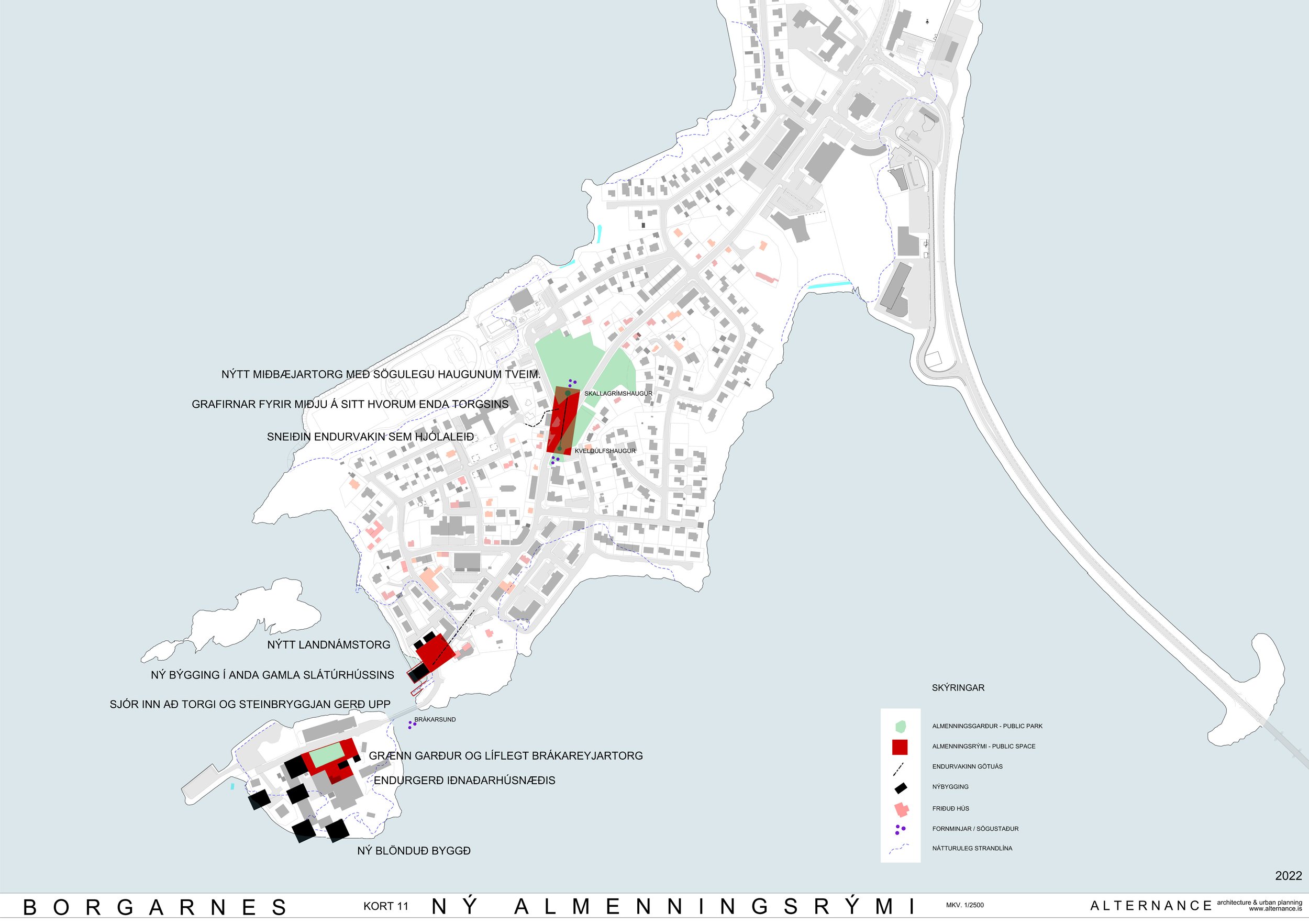
Proposal for new public spaces
Of the areas that were considered, three are chosen, i.e. those who were considered the most reputable to bring life to the old part of the town. The proposal aims to create a chain of interesting public spaces that have an attraction and encourage people to stay longer in the town and enjoy it actively. It is important that the connections between the public spaces are attractive, as well as creating an interesting connection between Brúartorg and the new central square for pedestrians and cyclists, but such a connection will weigh heavily in bringing life to the old part of town. Each of the three highlighted public spaces is roughly outlined on maps. In the following, the reasons for the selection of each area are briefly presented, but apart from that they are connected to each other and participate in forming a stronger whole.